Rock of Dunamase

When all else fails… walk away for a weekend, or a day, or even a few hours. Get out of your comfort zone, take a breath, and then you can come back renewed with a new vision and perspective on whatever it is overwhelming you in life and decide what to do. Sometimes we get too caught up being close to a problem, or stuck inside our heads. For our own mental health, we have to let go – just to be able to cope. And it’s okay.

Rock of Dunamase, the Castle ruins of the Norman knight Strongbow who married princess Aoife in 1170. Blown up by Cromwell's armies in 1670s. read more of the history at:   http://www.laois.ie/leisureandculture/heritage/laoisheritagetrail/rockofdunamase/

This is a hard lesson for many of us, and as someone who has had lots of challenges in my life I can easily see when my friends just need a break and time to walk away because they’re too close to a situation. Sometimes they can see it, sometimes they can’t, and sometimes as a friend, it means taking action for their own mental health as well as my own (because I worry and care about them). Back in January, a very good friend of mine was having some life challenges. So, because I adore her, I offered to meet up at a shop for lunch where I knew she’d be and give her a lift home. Only… little did she know, it would involve me “kidnapping” her for a spontaneous overnight trip, and just pointing the car in a direction and seeing what we saw. It would give her time out, and a little bit of a chance to breathe – and maybe help her feel better.

B and I met at the shop about noon, and loaded in the homewares purchases in the back of the car. On the way to her home, I said well, Lady, I’m sorry to do this, but in light of everything else – I’ve decided we’re going on a surprise trip. I’ve packed everything we need – toothpaste, toothbrushes, hairbrush, shampoo, etc. I have an extra t-shirt for the night and etc. The only thing I didn’t bring was a pair of undies for you – which we can get at a shop wherever we decide to stop (as well as anything else we forgot). I have a full tank of petrol, I have 150 euro, and well, my dear, pick a direction… because you’re in the car and not saying no. Here’s the map. Where haven’t you been?

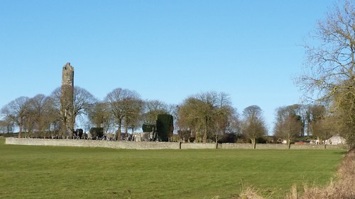
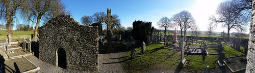
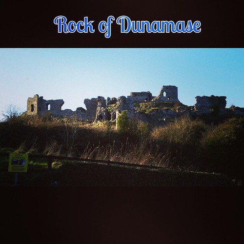
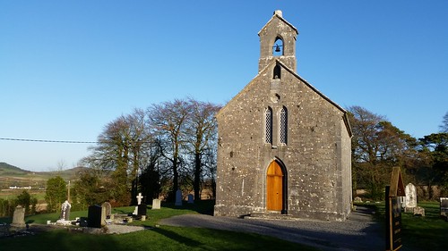
I was initially met with a bit of concern, and a little bit of frustration at this “unplanned” trip, but in the end, God love her, B called the nail salon and cancelled her appointment, and decided to just go with it. So, we headed west… toward Portlaois and about an hour in saw an interesting brown “point of interest” sign for the Rock of Dunamase. I pulled off the highway at the exit, and after some driving about rolling hills, getting lost and then returning to where we originally exited, we ended up going down a narrow twisty road and parking in front of a pretty little brick church – across from which was a little hiking hill –

Rock of Dunamase, Ireland

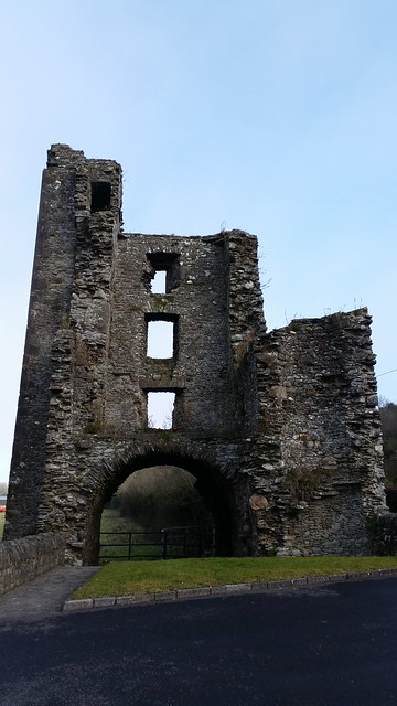
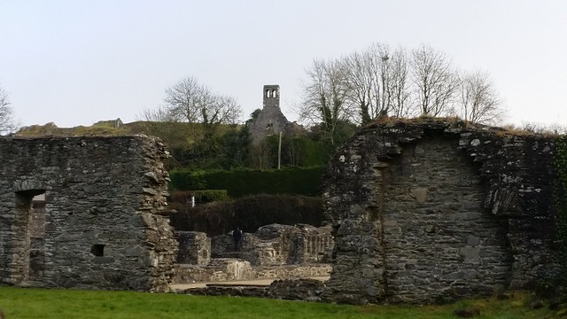
and the ruins of an old Castle, sitting at varying terrace levels high upon the hill.

Rock of Dunamase, Ireland
.

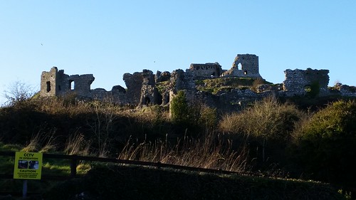
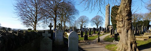
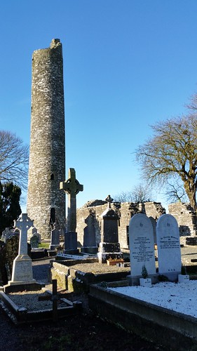
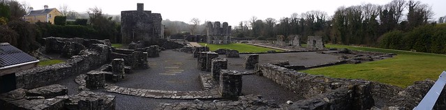
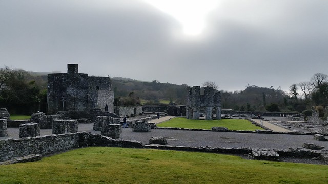
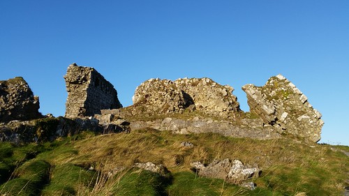
This then, was the ruins of Rock of Dunamase. It’s owned by the OPW (office of Public Works) here in Ireland, and it’s a free unmanned site which anyone can enter through a gate and go explore. As it was a sunny (but super cold) day in January there was no one about and we proceeded in. There we read the sign and learned that the castle was built in the 1100’s on top of an old 9th century fort (Dun in Irish) by the Anglo-Normans. Only it wasn’t just any “Normans”. It happens to be one of my personal “favorite” Normans – the famed Strongbow.

Rock of Dunamase, Ireland

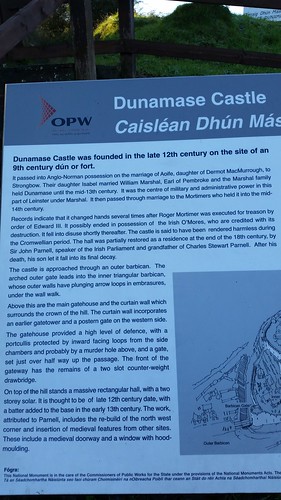
Way back in the 1100s (pre Norman Invasion), the main landowner in the region was an Anglo / Irish King called Dermot MacMurrough. He built a castle / fort on top of the hill locally known as Dunamase (Dun Masc aka Masc’s Fort) where there had been previous fortifications (those old fortifications had endured 2 different Viking raids before the hill fort became dormant for about 100 years). At the time, King Dermot controlled much of what is present day Dublin, up the coast to Newry, and down to Wexford and Wicklow- and then across to Longford, Kilkenny and PortLaois, the old kingdom called “Leinster”. However, King Dermot was kicked out of Ireland by a neighboring King O’Rourke and the Irish because he kidnapped the King O’Rourke’s wife and took her to the newly built castle.

Rock of Dunamase, Ireland

Around 1170, King Dermot MacMurrough negotiated with the Norman knight Strongbow to marry his daughter, the princess Aoife in 1170, and granted the castle structure to Strongbow as part of Her dowry. In return, Strongbow agreed to assist King Dermot regain his lands… and thus begun the Norman invasion of Ireland. They were successful, and not long after, Princess Aoife and Strongbow (Strongbow’s buried in Christchurch Cathedral in Dublin where you can see his likeness there today)
lived at the castle, and had a daughter, Isabel. Isabel was married off to William Marshal (Earl of Pembroke) in the 1200’s, and he took over the castle (Strongbow moved to Dublin area) and had 5 sons and 5 daughters. From here, the Marshal / Pembroke Earls held the castle until the middle 1200’s, when the last of the males died with no children. It was the center of administrative power in the region.

Rock of Dunamase, Ireland
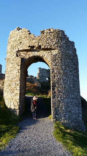
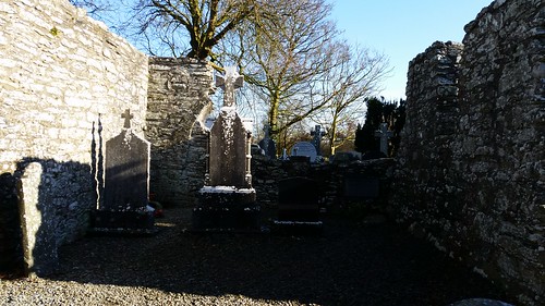
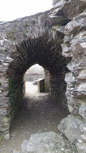
The barbican gate ruins

Rock of Dunamase, Ireland
The Moat

By the mid 1200’s, when there were no male hiers to the Dunamase, it was passed to the first of William’s daugthers, and subsequently the granddaugther, Maud Marshal-Mortimer. By then, Maud was married to Roger Mortimer (a Welsh lord under the Henry III). They had a son, also named Roger (I call him Roger Jr from here out) – whom, after inheriting the castle bounced loyalties back and forth between the English and the Welsh in a bid for power.

Rock of Dunamase, Ireland
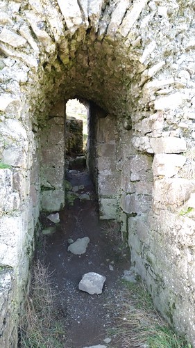
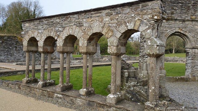
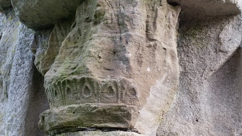
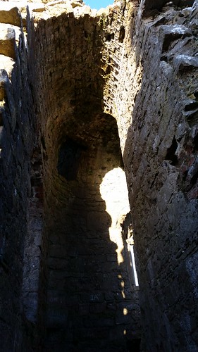
Narrow entry between buildings

Rock of Dunamase, Ireland
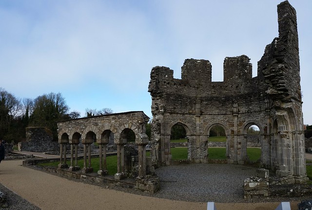
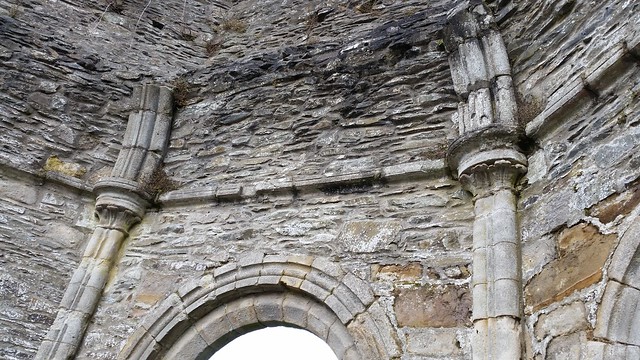
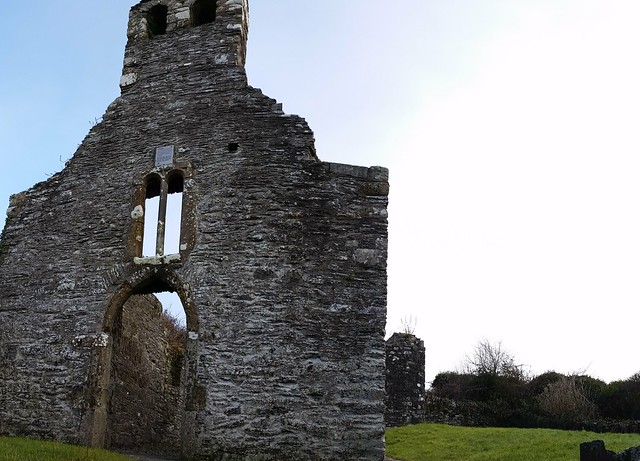
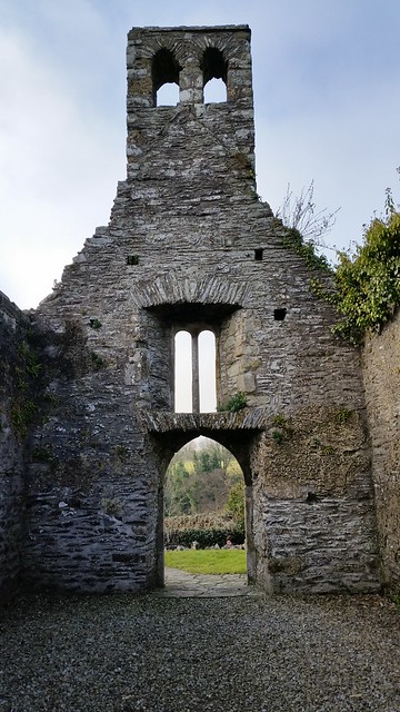
The Main hall entry (2 stories)

Rock of Dunamase, Ireland
Looking up at the vaulted ceiling from part of original entry

Rock of Dunamase, Ireland
main Hall & part of chapel

Roger Jr, interestingly – was appointed Lord Lieutenant of Ireland in 1316, and was imprisoned in the Tower of London in 1322 because he led the a revolt against King Edward II (the Despenser War). Roger Jr. later escaped and went to France, where he was joined by Edward’s queen consort Isabella, whom he took as his mistress. After he and Isabella led a successful invasion and rebellion, Edward was subsequently deposed; and Roger Jr. allegedly arranged the murder of Edward II at Berkeley Castle. Meanwhile, for three years, Roger Jr. was the de facto ruler of England before being himself overthrown by Edward’s eldest son, Edward III. Accused of assuming royal power and other crimes, Roger Jr. was executed for treason in 1330.

Rock of Dunamase, Ireland
Right side – some knocked over curtain walls

Rock of Dunamase, Ireland
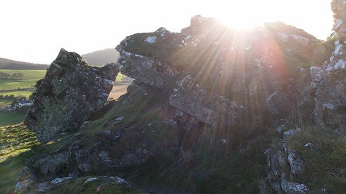
This must have been a hell of an explosion – this is parts of a wall blown up by Cromwell’s forces.

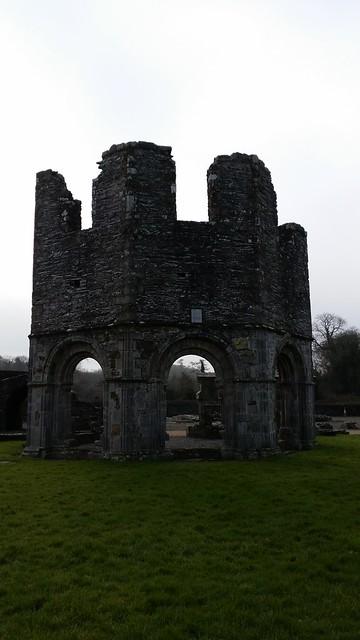
Sometime around 1350, the disgraced Mortimer family was out – and the castle at Dunamase had become a ruin of it’s former self. The only other bit of history of note was that in the 1670’s, Cromwell’s armies planted explosives around the castle ruins and blew them up to keep the revolting Irish from using them as defense fortifications. It must have taken some serious explosives (see the pictures below) because the walls were all 4-6 feet thick (or wider) and literally knocked wonky in places (above).

Rock of Dunamase, Ireland

Rock of Dunamase, Ireland

Rock of Dunamase, Ireland

Rock of Dunamase, Ireland
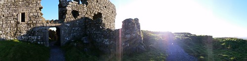
Panroama over the valley below

From the Rock of Dunamase, we headed through Abbyleix and on to Kilkenny for the night. More on our night in Kilkenny tomorrow.

if you want you can read more of the history at: http://www.laois.ie/leisureandculture/heritage/laoisheritagetrail/rockofdunamase/

Share

Monasterboice Abbey, County Louth, Ireland

Sunday Drive around Drogheda Part III (Final)

Monasterboice Abbey dating from 560 AD. 3 high crosses and round tower date to 10th century.

From Old Mellifont Abbey, now that the weather was clearing up a bit, I continued my Sunday drive another 8km (about 4 miles) down the main road further into the countryside to check out Monasterboice Abbey. With each passing kilometer, I was effectively moving back in time (Drogheda founded in 1194, Mellifont Abbey founded 1142) and in history.

Monasterboice Abbey dating from 560 AD. 3 high crosses and round tower date to 10th century.

The area in and around Monasterboice has had a long history. It’s a free site which you can visit, and it sits in the middle of several fields and down a long single track lane road. As you approach, you can see that it was a pretty impressive settlement – especially with the round tower visible from far away. Closer up, the gates reveal that there are the old style “steps” which kept the abbey secure and held in the livestock – but allowed for entry/exit of people.

Monasterboice Abbey dating from 560 AD. 3 high crosses and round tower date to 10th century.

The region has some pre-christian artifacts that have been discovered, though it’s unclear how they relate to this particular site and religious practices. The “current” site at Monasterboice was founded by Saint Buithe sometime at the end of the 4th century / beginning of the 5th century AD (Saint Bruithe died in 521 AD). It is from the Saint that the nearby River Boyne gets its name.

Monasterboice Abbey dating from 560 AD. 3 high crosses and round tower date to 10th century.

Other than a list of the Abbots who served the Abbey between 759 and 1122, there is little known about the history of the monastery. Some documentation shows that the Monasterboice was raided by the Vikings. The 30 Meter high (110 foot) Round tower was built in the 9th century to help see the raiders before they came. The 4 story tower served both as the watchtower/ belfry (to warn of attack) and also the treasury where books, relics, and other religious items were kept. It was also a place of refuge for the monks in times of need (The door is part of the way up the wall, accessed by a ladder which was pulled into the door during raids). (looking up at the tower from ground level below, and the ladder inside).

Monasterboice Abbey dating from 560 AD. 3 high crosses and round tower date to 10th century.

Monasterboice Abbey dating from 560 AD. 3 high crosses and round tower date to 10th century.

In 950s AD, (Some 400 years after Monasterboice’s founding) the Vikings finally did capture the site and held on to it until 968 AD when there was a great slaughter of the Vikings in the region by Brian Boru (Leader of the Irish) in an attempt to drive them out of the region. They were only temporarily successful, however, as the Vikings did continue to raid the region. The Round tower and parts of the complex were burned in 1097 along with all the books contained in the monastery.

Monasterboice Abbey dating from 560 AD. 3 high crosses and round tower date to 10th century.
(view from round tower steps looking toward the South church)

Finally, in the 1100’s the Normans came to Ireland, and it was the beginning of the end for the settlement at Monasterboice. Once Old Mellifont Abbey was built in 1142, the main facilities here slowly went into decline. By the 13th century, only a small parochial church presence was maintained in 2 small church buildings (built in the 14th century) the ruins of which can still be seen today.

The South Church – formerly made up of Nave and Chancel, with archway in the back wall:

Monasterboice Abbey dating from 560 AD. 3 high crosses and round tower date to 10th century.

Monasterboice Abbey dating from 560 AD. 3 high crosses and round tower date to 10th century.

Monasterboice Abbey dating from 560 AD. 3 high crosses and round tower date to 10th century.

Monasterboice Abbey dating from 560 AD. 3 high crosses and round tower date to 10th century.

Monasterboice Abbey dating from 560 AD. 3 high crosses and round tower date to 10th century.

The North Church – where the east windows and most of the “gable” are gone:

Monasterboice Abbey dating from 560 AD. 3 high crosses and round tower date to 10th century.

Icon niche:

Monasterboice Abbey dating from 560 AD. 3 high crosses and round tower date to 10th century.

Window:

Monasterboice Abbey dating from 560 AD. 3 high crosses and round tower date to 10th century.

In addition to the impressive Round tower from the 10th Century, and the ruins of the 2 churches, there are also 3 high crosses made of carved sandstone on the site, two of which are supposed to be the finest in all Ireland. These High Crosses were used to tell Biblical tales to those that couldn’t read (similar to how the Gothic churches used the stained glass windows a few centuries later). The most famous of the High Crosses is Muiredach’s High Cross, and it is 5.5 meters (16 feet) high and sits just to the right as you enter. The cross is named after the abbott at the time it was built (Muiredach mac Domhnaill) who died in 923 AD, and whose name is inscribed on the base.

Monasterboice Abbey dating from 560 AD. 3 high crosses and round tower date to 10th century.

According to Sacred Destinations website the carvings on the Muiredach’s cross represent a theme of Sin/Sinners and Christ’s saving of the people. (See the linked site for a much more detailed explanation of all 3 crosses).

Monasterboice Abbey dating from 560 AD. 3 high crosses and round tower date to 10th century.

Monasterboice Abbey dating from 560 AD. 3 high crosses and round tower date to 10th century.

Monasterboice Abbey dating from 560 AD. 3 high crosses and round tower date to 10th century.

Monasterboice Abbey dating from 560 AD. 3 high crosses and round tower date to 10th century.

The second cross is called the “west cross” or the high cross – and is next to one of the church ruins / directly across from the round tower. This cross is about 7 meters (23 feet) high. It’s slimmer than the others but actually has more carving due to its respective height. This too dates to around the 900 ADs and has a theme of miracles and Heroism performed.

Magalithic Ireland website has another decent description of the depictions on this cross but include Moses smiting water from a rock, David with Goliath’s head, and Samuel Anointing David, and the Resurrection to name a few.

Side 1:

Monasterboice Abbey dating from 560 AD. 3 high crosses and round tower date to 10th century.

Monasterboice Abbey dating from 560 AD. 3 high crosses and round tower date to 10th century.

Monasterboice Abbey dating from 560 AD. 3 high crosses and round tower date to 10th century.

Monasterboice Abbey dating from 560 AD. 3 high crosses and round tower date to 10th century.

Monasterboice Abbey dating from 560 AD. 3 high crosses and round tower date to 10th century.

The third and final cross on the site is known as the North Cross, and is very simply carved. It was smashed by Oliver Cromwwell’s forces but has been repaired since, and the base has also been replaced. It’s contained behind a metal fence with the original shaft propped nearby and along side it is a sundial and a few “ruine” stones.

Monasterboice Abbey dating from 560 AD. 3 high crosses and round tower date to 10th century.

Monasterboice Abbey dating from 560 AD. 3 high crosses and round tower date to 10th century.

Personally, I found the place quite peaceful on a Sunday morning. There were a few dog walkers out enjoying the countryside as I pulled in, and an older couple tending the family graves. As we were about to leave, they struck up a brief conversation asking where I and a couple others exploring the site were from. Amusingly, the other two ‘visitors’ were also from the US and proceeded to comment on the heritage and history of Ireland. 🙂 I recommended a few other local sites, and they headed on their way.

Monasterboice Abbey dating from 560 AD. 3 high crosses and round tower date to 10th century.

If you’d like to see a few more pictures of the location, you can see the full set here.

Share

Old Mellifont Abbey

February day trip around Drogheda, Part II.

Old Mellifont Abbey dating to the 11th Century AD.

Yesterday, I told you about a brief visit to the town of Drogheda. After I had a coffee to warm up, I decided that it was worth driving the 10 km through the countryside to the Old Mellifont Abbey Ruins. The weather was starting to look more promising, and the fog was starting to burn off the hilltops.

Old Mellifont Abbey dating to the 11th Century AD.

I was hopeful that the fog would be at the Abbey Ruins still, to make for some interesting photographs. Lucky for me, when I arrived, the visitor center (formerly Ireland’s first youth hostel) was closed, there was only one small family about, and we had the place pretty much to ourselves because of the cold and poor weather. As the day warmed up though – you can see in the pictures that the fog turned to sun and changed the mood entirely.

Old Mellifont Abbey dating to the 11th Century AD.

Old Mellifont Abbey was founded in 1142 by St. Malachy and was one of the first Cistercian Monasteries in Ireland. It sits on the river Mattock, which runs cheerfully bubbling through the countryside of green rolling hills. By 1170, the abbey had become an example for other abbeys built in Ireland and France architecturally. It was populated by 100 monks and 300 lay persons at the height of its influence. In 1539, it was closed (Henry the VIII) and taken over becoming a fortified house (the entry gate dating to the 15th century below).

Old Mellifont Abbey dating to the 11th Century AD.

In 1690, William of Orange used the fortified house at Mellifont Abbey as his headquarters during the Battle of the Boyne. Sadly, not long after the house went into ruins. There are only a few portions that are visible. You can walk about and see the knee high wall remnants for most of the site. The few higher walls that remain are an octagonal shaped section that dates back to the 13th century called the Lavabo. This is where the monks washed their hands before eating.

Old Mellifont Abbey dating to the 11th Century AD.

Reverse side Lavobo and some of the details like the arches, stonework, and windows:

Old Mellifont Abbey dating to the 11th Century AD.

Old Mellifont Abbey dating to the 11th Century AD.

Old Mellifont Abbey dating to the 11th Century AD.

Old Mellifont Abbey dating to the 11th Century AD.

Old Mellifont Abbey dating to the 11th Century AD.

The other sections of interest are the 14th century Chapter house (with Romanesque arches and tiled floor) from about 1220:

Old Mellifont Abbey dating to the 11th Century AD.

Old Mellifont Abbey dating to the 11th Century AD.

Old Mellifont Abbey dating to the 11th Century AD.

and the arched wine cellar (upper right hand corner of the picture below):

Old Mellifont Abbey dating to the 11th Century AD.

As well as the stone walkway to keep one dry going between buildings:

Old Mellifont Abbey dating to the 11th Century AD.

Up the hill there’s the walled ruins of a small chapel (center of the picture directly below) which you can find an old celtic cross gravestone.

Old Mellifont Abbey dating to the 11th Century AD.

Old Mellifont Abbey dating to the 11th Century AD.

Old Mellifont Abbey dating to the 11th Century AD.

Old Mellifont Abbey dating to the 11th Century AD.

You can see a map of the general layout of the abbey pre -becoming ruins here:

Old Mellifont Abbey dating to the 11th Century AD.

Old Mellifont Abbey dating to the 11th Century AD.

Old Mellifont Abbey dating to the 11th Century AD.

Overall the site is worth a visit just to see the layout, and because it is “free” to visit (not sure about the visitor center). I found out later that the visitor center has a good display of the architectural ruins and artifacts that have been uncovered in the area. I may need to go back to check this out. Otherwise, from here I headed back in time – to the Monasterboice Abbey Ruins – which dated to the viking times (1000 years younger) and was closed with the start of the Mellifont Abbey. More on that tomorrow.

For now, feel free to see more pictures from Mellifont Abbey in my flickr photostream.

Share